A lot of gray there....
+14
Scorpius
Hole
magnumcromagnon
Kimppis
Odin of Ossetia
JohninMK
Godric
Firebird
VladimirSahin
George1
Cyberspec
TheArmenian
GarryB
alexZam
18 posters
Interesting maps and infographics

GarryB- Posts : 40541
Points : 41041
Join date : 2010-03-30
Location : New Zealand
- Post n°101
 Re: Interesting maps and infographics

kvs- Posts : 15857
Points : 15992
Join date : 2014-09-11
Location : Turdope's Kanada
- Post n°102
 Re: Interesting maps and infographics
GarryB wrote:A lot of gray there....
The lack of solar/PV is rather surprising. I expected more. America is in much better geographic placement compared
to most of Europe and Russia.

JohninMK- Posts : 15643
Points : 15784
Join date : 2015-06-16
Location : England
- Post n°103
 Re: Interesting maps and infographics
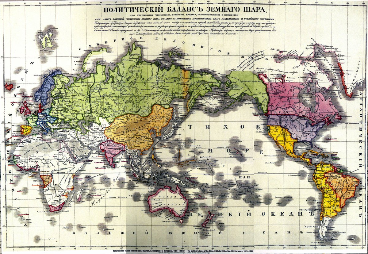
A larger land mass than the British Empire?
MapPorn
@MapPornTweet
· 8h
Zenith of Russian Empire, 1830 https://redd.it/a2s621 #MapPorn

MapPorn
@MapPornTweet
· 8h
Zenith of Russian Empire, 1830 https://redd.it/a2s621 #MapPorn

GarryB and Hole like this post

GarryB- Posts : 40541
Points : 41041
Join date : 2010-03-30
Location : New Zealand
- Post n°104
 Re: Interesting maps and infographics
Love old maps from before white european colonialists went around and divided all the know resources of the time up into packages they could claim as colonies...
100 years ago today they were creating countries in the middle east... which is not to say the ME is brand new and owes anything at all to Europe... there are places there with thousands of years of history that puts Europe to shame, but it is a western thing to be a country and have a flag and they managed to impose that on everyone... a country without a flag could be stolen by their rules...
100 years ago today they were creating countries in the middle east... which is not to say the ME is brand new and owes anything at all to Europe... there are places there with thousands of years of history that puts Europe to shame, but it is a western thing to be a country and have a flag and they managed to impose that on everyone... a country without a flag could be stolen by their rules...

Odin of Ossetia- Posts : 946
Points : 1033
Join date : 2015-07-03
- Post n°105
 Re: Interesting maps and infographics
How Foreign is Each Team at the 2022 Football World Cup?
https://www.vox.com/c/world/2022/12/8/23471181/how-migration-has-shaped-the-world-cup
My comments:
The "nationality" should be citizenship.
Some of the national teams look very deceptively "pure" according to the above Web page but in reality they are not, for example England and the Netherlands, you can see this only by looking at some of their players.

JohninMK- Posts : 15643
Points : 15784
Join date : 2015-06-16
Location : England
- Post n°106
 Re: Interesting maps and infographics
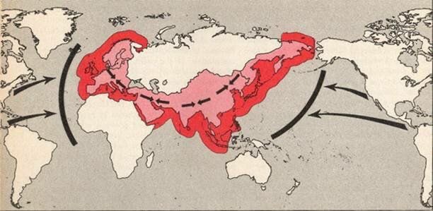
Sir Halford John Mackinder (1861–1947) was a British geographer, academic, and politician. He is best known for his work in geopolitics and is considered one of the founders of this field. Mackinder's geopolitical concept, often referred to as the "Heartland Theory," posits that control of the Eurasian landmass, particularly the vast "Heartland" region in the center of the continent, is essential for achieving global dominance. According to this theory, the nation or alliance that gains control over the Heartland can potentially dominate the world. Mackinder's ideas were influential in shaping geopolitical thinking and have been discussed in the context of various historical events and international relations strategies.

If you are more interested check the details of this follow up model:
Nicholas J. Spykman (1893–1943) was a Dutch-American political scientist and geographer who developed the Rimland Theory, a new model of world order. Building upon Mackinder's ideas, Spykman emphasized the strategic significance of the coastal Rimland surrounding the Eurasian landmass. He believed control over the Rimland was crucial for preventing the domination of the Heartland and maintaining global stability. Spykman's theory influenced U.S. foreign policy and the Cold War containment strategy by highlighting the importance of coastal regions in shaping international relations.
A more modern (2014) analysis of those thoughts.
http://nordstreambymortymer.blogspot.com/2023/02/mackinder-roadblocks-against-euro-asian.html
kvs likes this post

Odin of Ossetia- Posts : 946
Points : 1033
Join date : 2015-07-03
- Post n°107
 Re: Interesting maps and infographics
Population Growth of the Palestinians in the Palestine.
https://www.macrotrends.net/global-metrics/countries/HRV/palestine/population
By "Palestine" I guess they mean the West Bank and the Gaza Strip.
Clearly until 2023 there was no genocide of the Palestinians, the data available does not support such a claim.

kvs- Posts : 15857
Points : 15992
Join date : 2014-09-11
Location : Turdope's Kanada
- Post n°108
 Re: Interesting maps and infographics
They only got ethnically cleansed. The West Bank was essentially all Palestinian in 1967. Now its almost all the possession of Israeli settlers. And no, they did not
buy this land.
buy this land.
GarryB likes this post

Odin of Ossetia- Posts : 946
Points : 1033
Join date : 2015-07-03
- Post n°109
 Re: Interesting maps and infographics
They got ethnically cleansed but without being genocided.
And your claim that the West Bank is almost entirely Jewish by now is not really true.
See this map:
https://www.google.com/url?sa=i&url=https%3A%2F%2Fwww.newarab.com%2Fopinion%2Fnormalisation-doesnt-advance-israelipalestinian-peace&psig=AOvVaw0goPlwooK5i2-FdcAXNUdF&ust=1728325302305000&source=images&cd=vfe&opi=89978449&ved=0CBQQjRxqFwoTCIibgN-v-ogDFQAAAAAdAAAAABAJ
At least until 2023 they were not being genocided.

GarryB- Posts : 40541
Points : 41041
Join date : 2010-03-30
Location : New Zealand
- Post n°110
 Re: Interesting maps and infographics
Your maps and infographics are not working.... you need to save them to your own computer and then click on the "Host an image" button rather than the "insert image" button.
The host an image button hosts the image on a data hosting website, while insert image hotlinks it to the page you found it on.
Most websites do not like hotlinking because it costs money when someone loads the images on their website but by hotlinking you are not visiting their page so they don't get traffic revenue from their advertisers.


 JohninMK