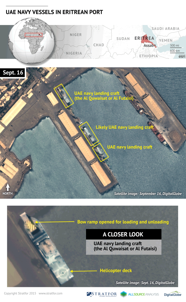
Or maybe due to this...?Militarov wrote:"Stratfor has detected an Emirati naval presence in the Eritrean port of Assab that may indicate Eritrea's support of the Saudi-led coalition in Yemen. Satellite imagery taken Sept. 16 appears to show three landing craft docked in the port that are not vessels known to exist within the Eritrean navy's inventory. Analysis of the detailed images provided by our partners at AllSource Analysis — and of naval vessels in the wider region — suggests that all three vessels belong to the United Arab Emirates. While there have been previous claims of Eritrea's support for the coalition conducting operations in Yemen, the naval activity in Eritrea's southern port reveals that Eritrean facilities and possibly even personnel are assisting the Saudi-led military effort.
Eritrea's exact role in the coalition's operations remains unclear and cannot be derived from this imagery alone. However, the presence of Emirati naval vessels indicates, at the very least, that Eritrea has assumed a direct military or logistical responsibility within the campaign. One of the landing craft located at Assab port was likely either Al Quwaisat or Al Futaisi, the only two ships of that particular class that were delivered to the United Arab Emirates in 2012. One of these ships was also spotted dropping off Sudanese troops and equipment at Yemen's Aden port on Oct. 17. It is therefore clear that Emirati landing craft are ferrying troops and equipment into the port of Aden as ground forces continue to mass ahead of a potential offensive push into Sanaa. Still, Eritrea's position in this scheme is less apparent."
http://www.weather.com/storms/hurricane/news/cyclone-chapala-yemen-oman-arabian-peninsula
Cyclone Chapala in the Arabian Sea Likely to Be Rare, Destructive Landfall in Yemen
Published Oct 31 2015
Cyclone Chapala became the strongest tropical system so far south in the Arabian Sea on record and may make an extremely rare landfall at hurricane strength along the coast of Yemen Monday or Tuesday.
Chapaa remained a Category 4 equivalent storm Saturday night after rapidly intensifying to a high-end Category 4 early Friday.
Satellite imagery Saturday showed a still-impressive eyewall with a tiny eye only about nine miles wide, roughly the size of Hurricane Patricia, which became the most intense hurricane of record in the western hemisphere roughly a week ago.
While direct measurements from reconnaissance aircraft are not available over the Arabian Sea, Chapala's rate of intensification from a high-end tropical storm to a high-end Category 4 storm in 24 hours ending 2 a.m. EDT Friday morning was quite impressive for this part of the world.


